KJIPUKTIK (Halifax) – A recently launched interactive map of Nova Scotia shows the close proximity of landfills, waste sites and other environmental hazards to many African Nova Scotian and Mi’kmaw communities throughout Nova Scotia.
Residents in communities such as Lincolnville, the Prestons, Cherry Brook, Acadia First Nation, Membertou and Eskasoni have long worried what these toxic dumps do to their health.
Now there is a way to visualize the issue.
The map was created by members of the ENRICH project. The project identifies environmental racism as a root cause for the close spatial connection between racialized communities and toxic industries.
“When I talk with civil servants I now have the map I can point to,” Ingrid Waldron tells the Nova Scotia Advocate. Waldron is an Assistant Professor at the Dalhousie School of Nursing and the tireless driving force behind the initiative.
“The map not only shows that there are waste dumps one or two kilometers away from a Mi’kmaw community of an African Nova Scotian community, but it also shows the location of that waste dump relative to white communities,” Waldon says.
“The way the map is structured you can see that waste dumps are much closer to African and Nova Scotian communities than to white communities,” Waldron says.
The map, created by ENRICH research assistant Beau Ahrens, is sophisticated but relatively easy to use. Features can be turned off and on, and map layers can be selected and deselected. A manual is available for download.
“What the people who created the map wanted is for it to become a lot more interactive, and user-friendly so that community members can use it, and upload additional layers with information. It is their map,” Waldron says.
“Eventually we want this broader tool, where community members can post audio, text, they can do whatever they want with it. That’s what we are aiming for.”
The map, which builds upon an earlier initiative by the Nova Scotia Public Interest Research Project (NSPIRG), has been almost a year in the making.
Make sure to also visit another new mapping-related initiative of this very energetic group of volunteers.
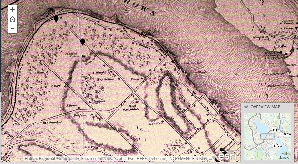
The Africville Story Map documents through the use of historic maps how through time the African Nova Scotian community was subjected to a slew of environmental hazards, a prison, and railroad tracks.
It makes you question to what extent things have really changed in Nova Scotia.


I would like to see PLFN added as effluent settling ponds from the Northern Pulp Mill & emissions impact on the health of the native community. Toxic trespass interferes with their use of their lands.