Michael William McDonald took a close look at who inhabited the District of Sipekne’katik, one of the seven districts of Mi’kma’ki, in the early 1700s, and posted the results of his extensive research on his Facebook page.
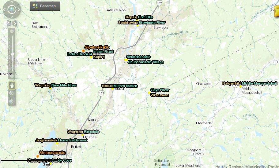
As this map by historian Daniel Paul illustrates, the District of Sipekne’katik, the ‘area of wild potato/turnip’, comprises the Shubenacadie District (including Kjipuktuk) and the Minas Basin Coast.
Michael’s work reveal the deep connection between the Mi’kmaq people and the landscape of Mi’kma’ki, the place the Mi’kmaq never ceded and have called home since time began.
We very much appreciate Michael’s permission to publish this essay on the Nova Scotia Advocate website, where it’s a great companion piece to his equally fascinating History of Halifax, a Mi’kmaw perspective.
Here is the list of known Clans in the District of Sipekne’katik in the early 1700’s. Each clan had their own Chief.
In 1720 Shubenacadie was comprised of two main Clans each with their own chief; Spring Brook (Chief Jean Baptist Fils debon) (Paul family originated from this clan) and Indian Brook (Chief Joseph Bomgabouidetche jr) (the Sack family originated from this clan)
Along the Shubenacadie river near where the Alton gas site is today was another large clan. (The Maloney family originated from this clan)
Musquodoboit which had a chief as well (Chief Joseph Bomgabouidetche sr.), included Musquodoboit Harbour and the mouth of the Musquodoboit River (the Abram family originated from this clan). North of Musquodoboit in Jeddore there was a large Mi’kmaq village in 1720 (The Stephens family originated from this clan).[1]
At one point a father and his son with same name represented the chiefs of Musquodoboit and Indian Brook which was the cause of much confusion.[2]
In Sheet Harbour there were two large clans. (The Howe family originated from one of these clans)
In 1718 there were around 600 to 1000 Mi’kmaq, living in and around Shubenacadie.[3]
There also was a clan in the Enfield area where Grand Lake spilled into the Shubenacadie River (the McDonald family originated from this clan). and another large clan was found along the Stewiacke River (The Julian Family originated from this clan).[4]
There was also evidence of smaller clans living along the Nine Mile River.[5]
Kjipuktuk (Chebucto/Halifax) there were three large clans, each with their own Chief (The Marr family originated from one of these clans). During the early 1700’s there were around 600 to as many as 2000 Mi’kmaq in Kjipuktuk. It is also recognized that there were two smaller clans in the North West Arm area (Horseshoe Island) and at the Narrows (Tufts Cove). (the Googoo family originated from Kjiputuk and Tufts cove clans)
In Lunenburg County the Mirligueche Mi’kmaqs lived in a large territory stretching westward from Mirligueche towards Mahone Bay, there were three main Clans and it is said they numbered 600 to 1000 Mi’kmaw in the early 1700’s. [6]
In 1715 there were 3 large clans along the Lahave river. (The Pennell family originated from one of these clans).
In 1720 Minas Basin had four main Clans and possibly more, but for sure the material shows there were two large Mi’kmaq villages in Minas represented by two Chiefs; Chief Nunquadden (the Newell family originated from this clan) and Chief John Qilalette (The Brooks family originated from this Clan) [7], also one chief in, St Croix (Jacques Necoute)(The Toney family originated from this clan) [8], and another in Piziquit (Chief Pierre Amquaret) (now Windsor).[9]
However, there is significant data that reveal three additional Clans in Kings County near what is now known as Kentville.[10].
There was a large Clan in Pinewoods situated north of Kentville and another Clan found on Cape Blomidon.[11] Data also show there were two extremely large villages which comprised 4 large clans but they disappeared around 1715. It is said they were wiped out by a mysterious plague.
In Cobequid (Truro) there were known to be at least three large Clans seen camping along the shores of the Salmon River (The Gloade, Martin and Cope families originated from these clans).[12]
These were all the main Clans at the times of the so called British acquisition of sovereignty in 1718. However there are numerous accounts of smaller Clans consisting of only one or two family’s scattered across the district of Sipekne’katik in a number of locations, mainly along the main waterways. In many of these locations, the land use by the Mi’kmaq were continuous and exclusive right up until the late 1800’s and into the 1900’s while a few are still occupied by Mi’kmaw to this day.
- [1] Tall Sails and Tall Tales, supra note 8 at p 105 to 106.
- [2] NSARM, MG-1, V.258, “March 10, 1760, Nova Scotia Council Minutes,”pp. 137- 40,” in “R. v. Stephen Frederick Marshall et al. Defence Document Books, vol.9,doc. 110”.
- [3] AN, (France), AC Cl ID, 10, “Sur L’Acadie, 1748,” in “R. v. Stephen Frederick Marshall et al. Defence Document Books, vol.7, no. 131″
- [4] Preston, Brian, An Archaeological Survey of the Shubenacadie River System 1970, Curatorial Report Number 18, Nova Scotia Museum, 1974.
- [5] Ibid.
- [6] “Sur L’Acadie” [1748], CUD, vol. 10, AC. On the general character of Mi’kmaq economic activities, see Virginia Miller, “The Micmac: A Maritime Woodland Group”, in R. Bruce Morrison and C. Roderick Wilson, eds., Native Peoples: The Canadian Experience (Toronto, 1986), p. 329; Patricia Nietfeld, “Determinants of Aboriginal Micmac Political Structure”, Ph.D. thesis, University of New Mexico, 1981, pp. 400-407.
- [7] PRO, (GB),CO 217, v.4, “Treaty of 1726, Indian Signatures,” in “R. v. Stephen Frederick Marshall et al. Defence Document Books, vol.7, no. 113”.
- [8] Speck, Frank G., Beothuk and Micmac, Part II, Micmac Hunting Territories in Nova Scotia and Newfoundland. 1914.
- [9] PANS, RG 1 23, ”Proceedings of Hibbert Newton, and Captain John Bradstreet with Gov. Saint-ovide at Louisbourg,” 30 August 1725.
- [10] Eaton, A. W. H., History of Kings County, The Heart of Acadian Land, The Salem Press Company, Salem Mass., 1910.
- [11] Ibid. (The English called it Cape Porcupine)
- [12] Patterson, Frank H, Acadian Tatamagouche and Fort Franklin, Truro:Truro Printing & Publishing, 1947.
Michael William McDonald is a Mi’kmaw lawyer specializing in Aboriginal, fisheries, criminal and family law
See also: Ta’n Weji–sqalia’tiek: Website explores deep Mi’kmaq roots in our landscape
Check out our new community calendar!
With a special thanks to our generous donors who make publication of the Nova Scotia Advocate possible.
Subscribe to the Nova Scotia Advocate weekly digest and never miss an article again. It’s free!